Capacity Building for the Utilization of Earth Observations among Utility Providers
Connect with an expert opens in a new pageChallenge
Energy systems are critical infrastructure, with electricity serving societal needs such as cooking, lighting, and transportation, to broader sustainable development. However, environmental factors, such as climate change, extreme weather or sea level rise, and social factors, such as population migration, threaten energy access, reliability, and overall community resilience. Vulnerabilities in the energy sector vary widely by component and geography. Successful strategies for resilience planning and uptake of renewable energy must include engagement with utility providers who can improve decision-making through the incorporation of Earth observations (EO) into routine planning and maintenance activities. Utilities require EOs on weather, climate, and other environmental parameters that impact electricity supply and demand, disrupt infrastructure such as power lines, or provide information for renewable energy resource assessment and integration. EOs are being used to map areas prone to disaster for risk management and to assess the aftermath of disasters for power.
However, actionable EO data should be within an appropriate decision-making scale of temporal and spatial resolution (near-real time versus seasonal versus decadal, city scale versus national scale). Further, Better collaboration between scientists and end users is needed so that data products are accessible and relevant to decision-making. Data should be accessible and understandable with multiple entry points for staff of varying degrees of expertise. Therefore, for this NASA grant, Battelle sought to assess the potential of utility end users to access and apply NASA EOs for energy management applications, including resilience planning and renewable resource assessment, and address key barriers preventing the uptake of NASA data.
The Solution
Battelle applied a capacity building approach to identify gaps, challenges, and opportunities through a secondary literature review, primary data collection through discussions with utility end users and other stakeholders, and a data mapping exercise to understand the possible NASA data products, tools, or resources most applicable for this user group. The capacity building approach emphasized the following key actions: assessing and understanding stakeholder needs, developing and applying processes and tools, transferring knowledge, co-developing or co-producing solutions, and engaging with stakeholders and partners. In addition to reviewing the scientific literature, government reports, and grey literature, Battelle reviewed over 120 NASA resources and assessed their utility and relevance for utility applications. Based on the secondary literature review and discussion with utility end users, we identified lack of awareness as a primary barrier to accessing NASA data. We also learned that not all NASA EOs were actionable; in other words, EOs may not be available in the right temporal or spatial resolution or in the right format (e.g. visualization or raw dataset, interoperable with datasets they may have internally or from other sources).
Given this context, Battelle identified datasets, tools, and products, as well as applications and case studies of interest to utilities that could leverage existing NASA data for various needs such as drought extent and potential, hydropower resource management, landslide susceptibility, periodic inland flooding, vegetation management, and wildfire potential. An ESRI StoryMap was developed and organized by both dataset and case study. The EOs included on the StoryMap were curated according to utility-specific needs to ensure actionability. The StoryMap will be reviewed by utility end users and other stakeholders, and will be revised and further refined according to feedback received. Once complete, it will be widely disseminated through various end user networks.
The Outcome
With access to actionable information, utilities have the ability to better plan for extreme weather, climate change, or energy portfolio shifts. Working through networks such as the Department of Energy Partnership for Energy Resilience, Edison Electric Institute, and Electric Power Institute, we will be able to access dozens of utilities across the U.S. Through engagement with the Group on Earth Observations (GEO), we will also be able to reach utilities and other stakeholders outside the U.S. who are interested in accessing NASA EOs for their applications as well.
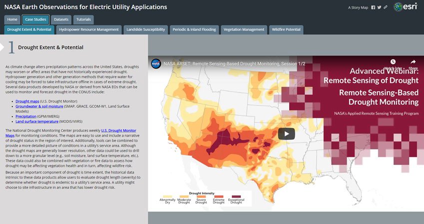
Screen capture of the ESRI StoryMap developed by Battelle to address known barriers in access to actionable information.
Screen capture of the ESRI StoryMap developed by Battelle to address known barriers in access to actionable information.
Case Studies
Technology Commercialization and Licensing
With over 90 years of research and development experience, Battelle supports all areas of industry with intellectual property licensing focused on bringing our cross-disciplinary expertise to meet our clients' most difficult challenges.
