Mapping the Vulnerability of Urban Populations to Extreme Heat Events
Connect with an expert opens in a new pageChallenge
The frequency and intensity of extreme heat events have been increasing globally and are projected to continue increasing through the 21st century. Compounding the rising average and extreme temperatures that are occurring with climate change, urban heat islands (UHIs) can add 6 to 8° C to urban temperatures compared to rural locations for many mid-latitude cities. UHIs can result from excess heat absorbed by built infrastructure, high vehicle emissions, and a lack of cooling. Extreme heat, which is exacerbated by the UHI effect and climate change, is the leading cause of weather-related mortality in the United States and many other countries.
The large populations concentrated in urban areas and their high degree of social stratification mean that social vulnerability to climate change is higher for some urban populations than others. Differences in demographic characteristics—as defined by income, education levels, race, social class, housing type and occupation, among other factors—are key contributors to overall vulnerability of a population to climate-related stressors and extreme weather events. Characterizing the spatial variability of exposure to heat and other stressors throughout a city, along with the variable sensitivity and adaptive capacity, can help policy makers and city managers identify vulnerable populations and design adaptation programs and policies to boost their resilience.
The Solution
Leveraging NASA funding, Battelle developed a methodology to analyze and visualize urban heat vulnerability in a way that could link science and policy, appropriate for supporting informed city-level policy and management decisions. Guided by an advisory group of local planners and end users in the pilot city of Philadelphia, Battelle identified the appropriate measures of social sensitivity, such as poverty, education level, age and access to air conditioning. We developed maps depicting areas of high social sensitivity (in red) in the Philadelphia urban area. We found that approximately 10% of Philadelphia’s population lives within the areas that are most vulnerable to extreme heat event health impacts. Allowing city-level decision makers and non-governmental organizations to visualize these areas can help them target adaptation efforts such as cooling centers.
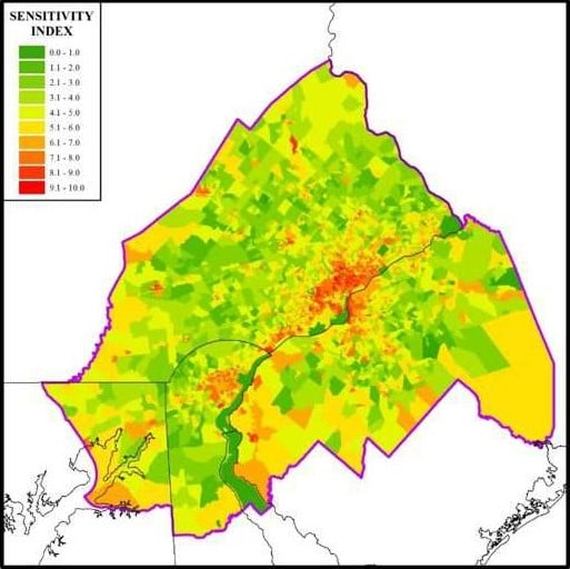
Philadelphia social sensitivity index by census block group
In quantifying spatial trends in exposure to extreme heat, we found that center city Philadelphia and nearby urban areas generally have higher Land Surface Temperatures (LST) and a lower Normalized Difference Vegetation Index (NDVI: a measure of “greenness” implying lower vegetation abundance and health) than the outer suburban and rural areas. Battelle also identified a trend of increasing urban temperatures using NASA data (MODIS LST data), confirmed with urban and rural temperature monitor data. Battelle found that most of the Philadelphia study area experienced an increase in July average LST of approximately 5° F per decade from 2003 to 2013.
The Outcome
The resulting maps of overall vulnerability can be used by local decision-makers for understanding patterns of vulnerability, providing the ability to better target adaptation measures and measure results (LST decrease or greenness increase) from existing adaptation measures (e.g., tree planting, green/cool roofs). This study offered an important approach to quantifying and mapping heat-related vulnerability for use by public health officials, policy makers and data users as they prepare climate change adaptation plans for their communities.
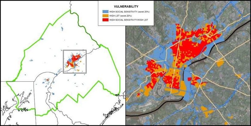
Residential locations (shown in red) of the most vulnerable populations to extreme heat as identified by high social sensitivity and high land surface temperature (exposure)
Case Studies
Technology Commercialization and Licensing
With over 90 years of research and development experience, Battelle supports all areas of industry with intellectual property licensing focused on bringing our cross-disciplinary expertise to meet our clients' most difficult challenges.
